


Pont de Montver Bedoues

darranger
User
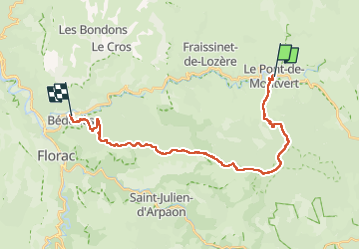

Length
24 km

Max alt
1420 m

Uphill gradient
767 m
Km-Effort
36 km

Min alt
564 m

Downhill gradient
1075 m
Boucle
No
Creation date :
2022-06-28 06:09:22.155
Updated on :
2022-06-28 15:27:37.037
6h38
Difficulty : Very difficult

FREE GPS app for hiking
 SityTrail
IGN / Geographical institutes
SityTrail Plus
The world is yours!
About
Trail Walking of 24 km to be discovered at Occitania, Lozère, Pont de Montvert - Sud Mont Lozère. This trail is proposed by darranger.
Positioning
Country:
France
Region :
Occitania
Department/Province :
Lozère
Municipality :
Pont de Montvert - Sud Mont Lozère
Location:
Unknown
Start:(Dec)
Start:(UTM)
559317 ; 4912464 (31T) N.
Comments